The key to conquering Toronto isn’t a map of the PATH, but an understanding of its role as the city’s central nervous system for efficiency, safety, and culture.
- Mastering the city’s flow means knowing when to use the TTC, when to walk underground, and which streets are safer due to “natural surveillance.”
- The PATH eliminates “transitional friction” in winter, making a 25-minute indoor walk significantly more efficient than a 34+ minute streetcar ride in the snow.
Recommendation: Stop thinking about the PATH as a series of tunnels and start using it as a strategic tool to access everything from tourist sites to local-only food spots, all while avoiding the city’s worst traffic and weather.
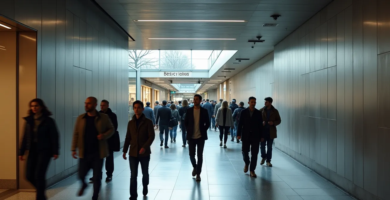
Welcome to Toronto. You’ve probably been told that to survive the winter and navigate the downtown core, you need to learn the PATH. You’ve likely downloaded a map, stared at the spaghetti-like connections, and felt even more overwhelmed. The common advice—”just follow the signs”—is a well-meaning but ultimately useless platitude when you’re caught in the riptide of rush hour commuters between Union Station and the financial district. Let’s be frank: treating the PATH as a simple underground sidewalk is the fastest way to get lost and frustrated.
The problem is, most guides treat the PATH as a maze to be solved. They focus on turn-by-turn directions, failing to explain the *system* itself. They don’t tell you that this 30-kilometre network is a public space, completely free to access, that operates as the city’s circulatory system. But what if the real secret wasn’t about memorizing a route, but about understanding the city’s flow? What if the PATH was less of a shortcut and more of a strategic motherboard connecting you to the city’s best-kept secrets, safest routes, and most efficient travel hacks?
This guide is your new playbook. We’re moving beyond the map. We will deconstruct Toronto’s interconnected systems—from street-level safety and transit efficiency to insider tricks for cultural events. You’ll learn not just how to get from A to B, but how to do it like a seasoned local who knows the city’s rhythm by heart. This is your upgrade from confused newcomer to savvy urban navigator.
For those who prefer a visual introduction, the following video offers an excellent tour of the PATH, illustrating the scale and connectivity of this incredible underground network. It perfectly complements the strategic insights you’re about to discover.
To help you master these concepts, this article breaks down the essential strategies into a clear, actionable framework. The following summary outlines how we’ll build your new mental map of Toronto, transforming you from a visitor into an insider.
Summary: An Urban Planner’s Guide to Toronto’s Inner Workings
- Why Walking Alone on King Street West Is Safer Than Sherbourne After 11 PM?
- TTC Streetcars vs. Walking: Which Is Faster for a 2km Commute in Winter?
- The 5 Kensington Market Food Stalls That Locals Keep Secret from Tourists
- The Rental Scam on Queen Street That Cost Newcomers Over $2,000 Last Year
- How to Visit the CN Tower and Distillery District in One Afternoon Without Uber?
- How to Park in Toronto’s Distillery District for Under $20?
- Does Auto-Park Actually Work in Tight Downtown Toronto Spots?
- How to Experience the Toronto International Film Festival (TIFF) Without a VIP Pass?
Why Walking Alone on King Street West Is Safer Than Sherbourne After 11 PM?
A newcomer’s first instinct is to gauge a city’s safety by its statistics. While it’s reassuring that Toronto consistently ranks as one of the safest major cities in the world, true urban safety isn’t about numbers—it’s about understanding street-level dynamics. As a seasoned urban planner, I can tell you that the feeling of safety is often a direct result of “natural surveillance”: the simple presence of other people engaged in legitimate activities. This is the core difference between King Street West and a street like Sherbourne late at night.
The Entertainment District, concentrated around King Street West between University and Spadina, thrives after 11 PM. The high foot traffic from bars, restaurants, and theatres creates a constant stream of “eyes on the street.” People are walking, waiting for rides, and socializing. This vibrant public life acts as a natural deterrent to crime. There’s safety in numbers, and on King West, the numbers are always in your favour. It’s a living ecosystem of urban nightlife.
In stark contrast, areas like Sherbourne Street, particularly the stretch between King and Bloor, have a different reputation among locals. Nearby areas like Moss Park are known for illicit activities, and the street has significantly less legitimate foot traffic after dark. Without the protective buffer of natural surveillance, these areas can feel isolated and “sketchy.” The lesson here isn’t to live in fear, but to live with awareness. General statistics are comforting, but knowing which micro-neighbourhoods have active, positive street life after dark is the real key to navigating the city confidently. This principle holds true even for a city that, according to The Economist’s 2024 safety ranking, is the safest in North America.
TTC Streetcars vs. Walking: Which Is Faster for a 2km Commute in Winter?
In the depths of a Toronto January, the question of the fastest commute becomes a matter of survival. Your gut instinct might be to hop on a TTC streetcar to cover a 2km distance, like from the Eaton Centre to Front Street. However, this is where newcomers’ logic clashes with the city’s reality. When you factor in winter conditions, the underground PATH system isn’t just a comfortable alternative; it’s often the most efficient one, largely due to a concept urban planners call “transitional friction.”
This image perfectly captures the dichotomy of a downtown winter commute. On one side, the harsh, unpredictable reality of surface travel; on the other, the controlled, efficient environment of the PATH.
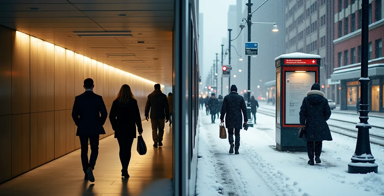
Transitional friction is the time and energy lost switching between environments: bundling up in layers, waiting in the biting wind for a streetcar that might be delayed or “short-turned,” then un-bundling at your destination. The PATH eliminates this entirely. You walk in a climate-controlled environment, maintaining a consistent pace without battling slush, ice, or wind chill. As the data shows, this makes a significant difference.
This table breaks down the hard numbers for a typical 2km downtown commute during a winter storm. It’s clear that while the streetcar seems logical, unpredictable delays and weather factors make it the least reliable option. The data is based on an analysis of Toronto traffic patterns in adverse weather.
| Transport Mode | Average Time (2km) | Winter Factors | Comfort Level |
|---|---|---|---|
| PATH Walking | 20-25 minutes | No weather impact | Climate controlled |
| TTC Streetcar | 34+ minutes | Short turns, delays | Variable heating |
| Outdoor Walking | 30-35 minutes | Wind chill, ice | Weather dependent |
Your Action Plan: Auditing the PATH for Peak Efficiency
- Identify your entry points: Map all direct access from key subway stations like Union, Dundas, or King to create your network.
- Inventory your landmarks: List key buildings (e.g., First Canadian Place, Scotia Plaza) that will serve as your mental waypoints, ignoring GPS.
- Audit the system’s logic: Confront the PATH’s color-coded signage (P-Red, A-Orange, T-Blue, H-Yellow) with your planned route to ensure directional consistency.
- Evaluate for efficiency: Pinpoint opportunities to eliminate ‘transitional friction’ by planning entire journeys underground, removing the need to bundle up.
- Create a flow-based route plan: Integrate your path through high-traffic zones like food courts during peak hours to use crowd flow as a natural guide.
The 5 Kensington Market Food Stalls That Locals Keep Secret from Tourists
The headline is a classic bit of clickbait, isn’t it? The truth is, in a place as thoroughly explored as Kensington Market, there are no truly “secret” stalls. The real secret is understanding context. A Bay Street executive’s “hidden gem” is a bustling food court spot in the PATH, while a Kensington local’s favourite is a place that values community over convenience. The idea of “5 secret stalls” is a tourist’s mindset; a local’s mindset is about finding the right food for the right moment.
Kensington Market’s soul lies in its multicultural, bohemian vibe. It’s where you find legendary spots like Pancho’s Bakery for churros or Rasta Pasta for its unique Jamaican-Italian fusion. These aren’t secrets; they are institutions. As Michelin-rated chef Steven Molnar points out, Kensington thrives on a community-driven food scene that is best experienced on a weekday afternoon when the tourist crowds have thinned, and the atmosphere is more relaxed and authentic.

So, instead of a mythical list of five, here’s the real insider’s strategy:
- Go on a Tuesday afternoon, not a Saturday morning.
- Follow the shortest line; it’s often a new vendor trying to make a name for themselves.
- Look for the places where people are speaking languages other than English.
- Ask a vendor what *they* recommend elsewhere in the market.
- Don’t look for a single “best” spot. The magic of Kensington is in the variety and the discovery.
This is the authentic way to experience the market’s flavour. The “secret” isn’t a location; it’s an approach. It’s about embracing the chaos and community, not trying to find a checklist item.
The Rental Scam on Queen Street That Cost Newcomers Over $2,000 Last Year
For a newcomer to Toronto, finding a place to live is the top priority, and this urgency makes you a prime target for rental scams. While Queen Street is a vibrant and desirable area, its popularity is exploited by fraudsters. The typical scam involves a “landlord” who posts a listing for a beautiful apartment at a below-market rate. They claim to be out of the country and ask you to wire a deposit—often first and last month’s rent—to secure the unit without a viewing. The apartment either doesn’t exist or isn’t for rent, and your money is gone.
This isn’t a rare occurrence. An investigation showed that the Toronto Police received 381 reports of rental scams targeting newcomers in 2024 alone, with many losing thousands of dollars. These scams prey on a lack of local knowledge and the pressure to find housing quickly. Your best defense is a healthy dose of skepticism and a firm set of rules.
Here is a non-negotiable safety checklist for any newcomer navigating Toronto’s rental market. Adhering to these points can save you from significant financial and emotional distress:
- Never send money without seeing the apartment. If you can’t go in person, have a trusted friend or representative go for you. No exceptions.
- Always use the Ontario Standard Lease Form. It has been legally required for most residential leases since 2018. If a landlord presents a different document, it’s a major red flag.
- Know the law on deposits. In Ontario, a landlord can only legally collect a key deposit and last month’s rent upon signing the lease. Asking for first month’s rent upfront, a “security deposit,” or any other fee is illegal.
- Be suspicious of deals that are “too good to be true.” Research median rental prices in the neighbourhood. A listing significantly below market rate is almost always a scam.
- Use the PATH to your advantage. Major bank branches are located throughout the PATH at hubs like Brookfield Place and Union Station. Use these secure, public locations for any in-person financial transactions or to get a certified cheque.
How to Visit the CN Tower and Distillery District in One Afternoon Without Uber?
A common newcomer mistake is treating Toronto’s top attractions as isolated destinations, relying on expensive and inefficient Ubers to hop between them. A savvy local knows that the city’s systems are designed to connect these points seamlessly. You can easily visit the CN Tower and the historic Distillery District in one afternoon without ever hailing a car, using the PATH as your primary strategic tool.
Here’s the playbook. This itinerary prioritizes efficiency and a bit of scenic enjoyment, proving that smart navigation trumps paying for traffic. It turns a logistical challenge into a pleasant urban exploration.
- 2:00 PM: Enter the System. Start by entering the PATH at a major northern hub like Dundas Station (next to the Eaton Centre). This is your entry into the underground highway. Navigate south, following the blue ‘T’ signs toward Union Station.
- 2:30 PM: Access the SkyWalk. Once at Union Station, look for signs to the “SkyWalk.” This is a crucial piece of infrastructure: an enclosed, elevated walkway that connects directly to the Metro Toronto Convention Centre and, from there, the base of the CN Tower. You’ll arrive without ever being exposed to weather or street traffic.
- 3:30 PM: The Scenic Connector. After your visit to the CN Tower, instead of backtracking, walk east along Bremner Boulevard towards the waterfront. This short walk takes you to Queens Quay.
- 3:45 PM: Choose Your Route. From Queens Quay, you have two great options. You can board the 172 Cherry Street bus, which will take you directly to the Distillery District. Or, for a more scenic route, walk east along the beautiful Waterfront Trail. On this path, you’ll pass Sugar Beach, a quirky urban park with its iconic pink umbrellas—a perfect photo opportunity.
- 4:00 PM: Arrive at the Distillery. Both the bus and the walk will deposit you at the entrance to the Distillery District’s cobblestone streets, ready to explore its galleries, boutiques, and cafes.
This entire journey showcases how the PATH isn’t just for commuters; it’s the backbone of an efficient tourist itinerary.
How to Park in Toronto’s Distillery District for Under $20?
Driving to the Distillery District is a classic Toronto paradox: you go to enjoy a historic, pedestrian-friendly village, but the journey there by car is a modern nightmare of traffic and exorbitant parking fees. On-site parking can easily run you $35 or more for a day. However, getting a spot for under $20 is entirely possible if you’re willing to think like a local and leverage the city’s transit systems—a strategy I call “Park & PATH.”
The core idea is to avoid the final, most congested and expensive “last mile.” Instead of driving directly to the destination, you park at a cheaper, peripheral location and use public transit to complete the journey. This not only saves you significant money but also the stress of navigating downtown traffic. The official on-site lots prey on convenience, but a little planning yields massive savings.
This table compares the true cost of convenience versus a more strategic approach. The data makes a compelling case for parking further away and enjoying the walk or a short transit ride. Data is compiled from municipal and private parking operator information like that found on the official City of Toronto website.
| Parking Option | Weekday Rate | Evening/Weekend Rate | Distance to Distillery |
|---|---|---|---|
| Official Distillery Lots | $25-35/day | $15 flat after 6pm | On-site |
| Green P Peripheral Lots | $18-22/day | $8-12 evening flat | 5-10 min walk |
| TTC Park & Ride (Kipling/Finch) | $7-9/day | $2 weekends | Subway + PATH connection |
The most cost-effective method is the TTC Park & Ride. You can park at a major subway station on the city’s outskirts, like Kipling or Finch, for a low daily flat rate. From there, you take the subway to Union Station. Once there, you can navigate part of the way through the PATH to avoid weather, then emerge for a streetcar or a pleasant walk to the Distillery. This strategy combines the convenience of a car for the long haul with the cost-effectiveness and stress-free nature of public transit for the most congested part of the trip.
Does Auto-Park Actually Work in Tight Downtown Toronto Spots?
The promise of auto-park technology is seductive: your car, gliding effortlessly into a tight parallel spot while you sit back and marvel. In the wide-open suburbs, it works beautifully. In downtown Toronto, it’s a recipe for anxiety and a potential insurance claim. The city’s parking infrastructure, especially in older underground garages connected to the PATH, was built long before these systems were conceived. They are, to put it mildly, unforgiving.
The sensors and algorithms in most auto-park systems are designed for idealized conditions. They struggle with the unique challenges of Toronto’s concrete jungles: the massive, oddly-placed pillars, the steep, spiraling ramps, and the aggressive impatience of other drivers who won’t give you the space or time the system requires. As one Toronto driving instructor noted in an interview on the city’s unique driving challenges:
The stress of parking is a key reason why mastering alternatives like the PATH and TTC is so liberating for navigating Toronto.
– Toronto Driving Instructor, Interview on downtown parking challenges
Trusting your car’s computer to navigate these hostile environments is a gamble. A seasoned Toronto driver knows how to spot an “auto-park death trap” from a block away. Here are the tell-tale signs:
- The Pillar Squeeze: A spot flanked by large concrete support pillars, common in many PATH-adjacent office tower garages. The sensors often can’t properly gauge the proximity, leading to scrapes.
- The Ramp of Doom: Any spot located immediately after a steep or sharply turning garage ramp, like the one at Nathan Phillips Square. The system can get confused by the change in angle.
- The Beam Hugger: Spaces next to protruding support beams where there is less than a foot of clearance. The car’s computer may see the space as viable, but it doesn’t account for the door-opening radius.
- The One-Way Pressure Cooker: Angled parking on a busy, narrow one-way lane where impatient drivers will be right on your bumper, giving the system no margin for its slow, multi-point adjustments.
The lesson is clear: in downtown Toronto, the best auto-park system is your own judgment and the decision to find an easier spot or, better yet, not drive at all.
Key Takeaways
- True urban safety comes from “natural surveillance” – the presence of people – which is why King West is safer than Sherbourne at night.
- In winter, the PATH is not just more comfortable, it’s often faster than surface transit by eliminating weather delays and “transitional friction.”
- Mastering Toronto’s systems (PATH, TTC) is the real secret to unlocking the city, from finding authentic food to visiting landmarks without a car.
How to Experience the Toronto International Film Festival (TIFF) Without a VIP Pass?
During the Toronto International Film Festival (TIFF), the city transforms. King Street becomes a pedestrian-only festival zone, and the area around the TIFF Bell Lightbox pulses with energy, celebrities, and massive crowds. For a newcomer, it can seem like an impenetrable fortress of VIPs and expensive tickets. But the real festival experience—the celebrity sightings, the last-minute screenings, the electric atmosphere—is perfectly accessible if you leverage the city’s secret corridor: the PATH.
During TIFF, the PATH becomes an unofficial “insider’s route.” It connects nearly all the major festival venues, including the Scotiabank Theatre, Roy Thomson Hall, and the TIFF Bell Lightbox itself. While tourists and fans battle the crowds on the street, industry professionals, festival staff, and in-the-know film lovers move quickly and discreetly underground. Hotels with direct PATH access, like the Ritz-Carlton, become celebrity hubs, and the cafes and restaurants within the PATH’s financial district hubs like Brookfield Place serve as quiet meeting spots away from the frenzy. The official PATH map shows these critical connections, but doesn’t hint at their strategic importance during the festival.
Your strategy is to join this underground flow. Forget trying to get a gala ticket; the real game is the “Rush Line,” where unsold tickets are available at a discount just before a screening. Here’s the rush line playbook:
- Target morning or afternoon screenings. The competition is far less fierce than for the evening premieres.
- Arrive 2-3 hours early. It’s a long wait, but often worth it.
- Venue-hop efficiently using the PATH. If a line looks hopeless at one venue, you can quickly get to another without surfacing. Enter at St. Andrew Station for Roy Thomson Hall or King Station for the TIFF Bell Lightbox.
- Retreat to PATH food courts. Between screenings, you can grab a cheap and quick meal in the PATH, avoiding the overpriced and overcrowded festival street food.
- Scout for celebrities strategically. Instead of waiting outside a theatre, hang out in the cafes of PATH-connected luxury hotels or financial towers. It’s where the real business of the festival happens.
By using the PATH, you transform from a passive spectator into an active, strategic festival-goer.
Now, stop just walking through Toronto and start moving with it. Your journey to becoming a true local begins by putting these system-level strategies into practice today.